Presbytery of Abertarff, Synod of Glenelg
Rapporteur: The Rev. James Doune Smith, Minister.
Drawn up by the Rev. J.D. Smith and George Anderson, Esq. Inverness.
[Biographical Notes for the Minister adapted
from the Fasti ecclesiae Scoticanae
JAMES DOUNE SMITH (1781- 1847) son of William Smith, minister of Petty; educated
at Marischal College, Aberdeen (MA 1798); licensed by the Presbytery of Inverness
5th February 1805; ordained as assistant chaplain at Fort-George 10th April
same year; afterwards missionary at Grantown; presented (to Urquhart & Glenmoriston)
by the curator for Lewis Alexander Grant, Earl of Seafield, October 1814; admitted
20th April 1815; J.P. (1818), D.L. (1820); died unmarried. ]
I: Topography and Natural History
Name
[36] The meaning of the word Urquhart is now unknown; but as there are several parishes of that name in the Highlands, Urquhart on Loch Ness was anciently called Urchudin Cill ma Chrossan, as being the residence of Saint Crossan or Crostan, and latterly as Urchudin Thiarna Ghrani, or the Laird of Grant's Urquhart. Glenmoriston or Glenmore-Essan, “the glen of the great waterfall”, derives its name from the beautiful cascades on the river which flows through it, of which those near the mouth are the largest and most picturesque. Anciently, the parish of Glenmoriston was united to that of Abertarff, and it is believed that it was when the latter was connected with Boleskine that the former was joined to Urquhart. Since the suppression of Popery, at least, the two parishes have had but one minister, the glebe and parish church being situated at Kilmore, on the margin of the bay of Urquhart, a portion of Loch Ness, being thus placed at the extremity of the larger but more populous district of Glen Urquhart.Extent and Boundaries
This exquisitely beautiful parish, which is more varied in mountain, hill, and dale, lake and stream, “the warbling wood, the pomp of groves and garniture of fields”, than perhaps any other in the Highlands, is about 30 miles long, and in general from 8 to 12 miles broad, though the extreme breadth along the northern bank of Loch Ness, from the confines of Aberiachan to Invermoriston, extends to about 16 miles. It is bounded on the north by the parishes of Inverness, Kirkhill, and Kiltarlity; on the east by Loch Ness; on the south by the united parishes of Boleskine and Abertarff, and part of Kilmonivaig; on the south-west by the parishes of Glenshiel and [37] Kintail in Ross-shire; and on the west and north-west by the district and alpine valley of Strathglass, which lies in the parishes of Kilmorack and Kiltarlity.Topographical Appearances
Glen Urquhart and Glenmoriston, which are the only transverse valleys branching off from the north side of Loch Ness, form the principal and most populous divisions or portions of this parish, the rest being high and mountainous, and resorted to only for pasture, and peat, which constitutes the natural fuel of the district.These glens, proceeding in south-west and nearly parallel direction, are respectively about nine and twelve miles long, and are separated by high heathy hills, which terminate immediately above Loch Ness, in the great round-backed mountain of Maulfuarmhonvie, or Mealfuarvonie, (literally, the height or lump of the cold moor) whose dome-shaped summit attains an elevation of 3200 feet; while, in the opposite direction, these valleys usher us to the plain of Corrymony and the ridges overhanging Strathglass on the one hand, and on the other to the great moorland or table-ground which stretches around Loch Cluany and the bases of the peaked mountains of Kintail.
Glenmoriston, except near its mouth, where it is flat and deeply sunk among the high steep pine and birch-clad hills which rise abruptly on both sides of it, is an inclined valley, expanding in width as we ascend and displaying in great extent and luxuriance the rounded forms and lively green of a birch forest, which stretch far up the mountain sides from the dark and mingled masses of native pine, oak, and roan-tree lining the rooky banks of the impetuous torrent, which forces its tortuous course along; the centre of the glen. It is hence but little cultivated, and the district is almost exclusively a pastoral one. The lower parts of the valley, indeed, are almost entirely covered with birches, and towards the interior the hills are crowned with noble woods of the Scotch fir or pina. Urquhart, on the other hand, expands first from the waters of Loch Ness into a beautiful semicircular plain, divided by regularly shaped fields and hedge-rows, and having all the hill sides above it beautifully diversified by woods and cultivated grounds, where persevering labour is seen overcoming all the obstacles of situation and climate, and carrying tillage to a great elevation. By the course of the river Coiltie, which waters the southern side of this plain, the receding and smaller sized stripes of corn ground are seen extending into the natural domains of the birch tree and brown heath of the upland pastures, while the Enneric water on [38]the west leads the eye past the white walls of the large and excellent inn of Drumnadrochit, (which corrupt word signifies "the height above the bridge,") beyond which a reach of two or three miles of haugh land (affording room for some of the best farms in the district and the site of its most populous hamlets,) conducts to a .rocky pass or gorge; on turning this we attain the upper or inland valley of Urquhart, which is almost circular, its centre being occupied by Loch Meikly, an elegant sheet of water, (about one mile long, and half a mile broad,) from the edges of which arise the green and highly improved lawns and cultivated grounds of Lakefield and Lochletter. Over a heathy ridge beyond these we reach, two or three miles farther on, the flat of Corrymony, which is adorned by some very large ash and beech trees, and where cultivation has been successfully introduced to a considerable extent, at a distance of twenty-five miles from the sea, and at least 800 or 900 feet above it.
Meteorology and Hydrography
The parish, from its inland situation, partakes of a mixed climate, intermediate between the excessive moisture of the west coast and the cold dry atmosphere of some of the eastern counties – the piercing blasts in spring which proceed from the German Ocean being less severely felt here than in the low country. The district is hence, on the whole, very healthy, and some of the inhabitants attain extreme old age.The line of junction between the primary and sandstone rocks described below is distinguished all round the parish by unusually great excavations and undulations of the ground, which, being partially filled with rainwater, have given rise to an almost continued chain of tarns, or small lakes or marshes in the higher districts; and these being bordered with rushes and belts of the white and yellow water-lily form the nestling places of large flocks of wild fowl. Of Loch Ness, the south-eastern boundary of the parish, no description need be given here, as an account of it more naturally belongs to another parish. At the base of the upper acclivity of Mealfaurvonie, which is perpendicular on the north and south sides, nearly so on the west, and connected by a long tapering ridge with the rest of the mountain on the east, a small circular lake exists which was once thought to be unfathomable, and supposed by the credulous neighbours to be united underground with Loch Ness, but which has now been found to be comparatively shallow. From its western extremity it discharges a small streamlet called Aultsigh or "the Resting burn," which, tumbling [39] down alone a rocky channel at the base of one of the grandest frontlets of rock in the Highlands, nearly 1500 feet high, empties itself into Loch Ness within three miles of Invermoriston. This burn constitutes the boundary between Urquhart and Glenmoriston; and, besides the magnificent rocky and woodland scenery with which its course is lined, it is farther worthy of notice as displaying near its mouth an unusually beautiful waterfall, and another equally fine one about two miles farther up, shaded with foliage of the richest dye. On the summit of the hill to the west of the burn, there is a rocking-stone, which two persons can move, about twenty feet in circumference.
This burn's parent lake is also supposed occasionally when swollen to send off a streamlet towards the north; or, at least, the hollow or rather deep ravine which collects the infant waters of the Coiltie, which flows along the southern margin of the vale of Urquhart, begins very near the northern extremity of this loch.
The Coiltie, from the elevation of its springs, is a most rapid and sometimes dangerous rivulet, which carries down enormous masses of stone that choke up its channel, and cause it to overflow its banks, and destroy, not only the corn land, but sometimes also houses and bridges.
A tributary of this water, called the Divach, amid beautiful and dense groves of birch, displays a waterfall as high and. picturesque as that of Foyers; and near the source of the Enneric river, which flows from Corrymony into the still basin of Loch Meikly, another smaller, though highly picturesque cascade, called the Fall of Moral, is to be seen. Near it, is a cave capable of receiving sixteen or twenty persons, in which several of the principal gentlemen of the district for a time concealed themselves from the Hanoverian soldiers after the Rebellion of 1745. The Falls of Divach are seldom supplied with a sufficiency of water to give them that decided grandeur which they possess when the rivers are in speat, as their swollen state is significantly called; but then the mountains’ sides are everywhere streaked round with foaming cataracts, which disappear on the return of fair weather. The burn which falls from Aberiachan on the confines of the parish of Inverness, displays a succession of beautiful perpendicular falls and running cataracts; and that of Aultguish, (or the Fir-tree burn,) in the forest of Ruisky, eastward of Aultsigh, presents a continuous cataract, which, from the lake below, looks like a long white ribbon streaking the [40] mountain side, and part of which consists of a single leap at least 100 feet high.
Geology
The whole neighbourhood of Loch Ness seems formerly to have been subjected to great volcanic action and large eruptions of granite; and although this parish does not exhibit much granite en masse, yet its primitive nocks everywhere display the intrusion of various sets of granitic veins.At the summit of Glenmoriston, and around Loch Cluany, a beautiful white porphyritic granite, with large distinct crystals of felspar, occupies an extensive tract of country. Beneath, in the glen itself, and along both sides of the river Moriston, stratified gneiss prevails; but at the eastern boundary of Urquhart, on the confines of the parish of Inverness, another large deposit of whitish granite occurs, which constitutes several of the hills encircling the moss of Caiplich, and is connected with the red granites of Dochfour and Aberiachan, described in the account of the parish of Inverness. From behind the farm of Polmailly in Glen Urquhart, a formation of unstratified serpentine rock proceeds in a north-west direction, constituting three prominent summits, with several subordinate ridges, and extending 2½ or 3 miles in length, and about 1 mile or 1½ in breadth. It is distinguished by the dirty-brown colour of the surface, and the extreme sterility of the hills formed of it – the serpentine here as elsewhere permitting but few trees, and hardly a blade of grass, to grow upon it. No beds of chromate of iron or other useful minerals have as yet been discovered in this deposit, which, however, has not been minutely examined, nor has the serpentine been polished or employed as an ornamental stone. It is contained in strata of gneiss, which abound in beds of gray and white primitive granular limestone, which is partially burnt and used for domestic purposes by the farmers of the district. The limestone contains very beautiful and numerous suits of actynolite, tremolite, and asbestus; besides which, several varieties of mica, hornblende, and bronzite, are occasionally found – the hornblende also occurring, both massive and slaty, and highly crystallized, in beds of various sizes, and discovered generally in contact with veins of granite.
But the most important rock, in a geological point of view, in this district, has yet to be noticed. It consists of a great overlying and unconformable deposit of old red sandstone and its associated coarse conglomerate, and constitutes the summits next to Loch Ness, and the lower and more fertile portions of the vale of Urquhart. This deposit has been superimposed on the gneiss [41] rocks, and upheaved in very many places from its original horizontal position by the granitic invasion from below. To what extent the altitude of Meolfaurvonie may be owing to granitic displacement we have no means of determining ; but it is remarkable that the great upper dome or rounded summit of this mountain} which is elevated, as already noticed, 3200 feet above the sea, is one entire mass of conglomerate rock, (the abraded portions consisting of granite, gneiss, mica-slate, quartz rock, and sandstone, cohering together almost without any basis or cement) and that the stratified sandstone at its base has been so indurated, probably from the influence of a subjacent but contiguous mass of granite, as in many places to have lost its distinctly stratified disposition, and to have acquired so hard and crystalline a texture as has rendered it fit to be used as a causeway stone for the streets of Inverness. The hardened variety has sometimes been described as quartz rock. This enormous sandstone deposit is now disjoined from the similar rocks which composed the eastern termination of the Great Glen by Loch Ness, and the granitic hills of Caiplich and Dochfour but when surveyed from Mealfaurvonie the conglomerate ridges of Foyers and Balliechernock, described in the Account of Dores parish, appear once to have been connected with it; while on the north, across the valley of Urquhart, the junction with the main eastern deposit of sandstone is completed through the upper braes of Kiltarity.
We have mentioned that the portion of Glen Urquhart next Loch Ness consists of the stratified sandstone and its associated conglomerate. Of the latter, almost all the eminences which surround it are composed; and beneath their rough and bare summits a broad plateau, gently declining towards the centre of the valley occurs – on the inner lip or edge of which the sides of the glen sink rapidly down, showing that the bases of the higher summits were at one time washed by a great body of water, which rested on the plateau just mentioned, and which subsequently discharged itself by the trough below forming the present course tit the river Enneric. In causing these excavations, the waters appear to have encountered three principal barriers: one now opened into Loch Ness, at the mouth of the valley, one stretching across from Craigmony, a little to the west of Drumnadrochit, and one at or above Dalshangy, where the separation between the upper and lower valleys is still visible. Several beautiful terraced banks, indicative of more recent [42] effects of water, encircle the vale of Urquhart on all sides, of which two are particularly distinct, (being elevated about 20 and 50 feet respectively above the level of Loch Ness) and which, from their horizontal surface and smooth sloping sides, furnish fine banks for young plantations, and picturesque sites for cottages.
The soils in this parish, though light, are on the whole warm and productive, and, from the prevalence of secondary rocks, rather more clayish than is common in Highland districts. The subsoil is (except where peat mosses have been reclaimed) universally gravel, more or less porous, and with which every hill side and every valley has been strewn over by ancient currents of water to a considerable depth.
There are no metalliferous mines in the district, and no beds of lime quarried to any great extent – the burnt lime of England, from the want of coals here, being on the whole to be got nearly as cheap as the local deposits could be wrought. Boulder, or loose field stones, are much used in the construction of houses and enclosures, and the only extensive quarry in the district is was opened in the sandstone (inclining to quartz rock) of Ruisky in front of Mealfaurvonie, and not much above the edge of Loch Ness, for supplying with large stones the works of the Caledonian Canal at Fort Augustus. It has not been used for some years, except to furnish paving or rather causeway stones for the streets of Inverness.
Botany
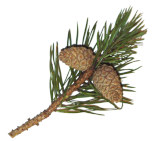
The banks of Loch Ness, and especially the portion between the bay of Urquhart and Invermoriston, are distinguished for the richness and variety of their vegetable productions. The space just mentioned contains the old forest of Ruisky, the top of which consists of native pine trees, with oaks, ashes, and hoary hawthorns, stretching in detached stems and clumps along the precipitous rocks, and which, descending below, mingle themselves with the dense woods of birch which cover all the lower acclivities to the water's edge. The sloe, holly, guelder-rose, trembling poplar, alder, mountain-ash, or rowan-tree, with long trailing brambles, and the largest sized white and red rose bushes, increase the variety and beauty of the foliage, and when mixed with hazel arid rasp bushes, create an almost impassable copse. Here and there are seen some enormous indigenous elms and gean trees; and throughout the district the beautiful white flowering birdcherry or hackberry, as it is called, (Prunus padus), is most abundantly distributed, and attains an uncommonly large size, while the gardens and pleasure grounds [43] at Invermoriston, Balmacaan, Polmailly, Kilmore, Lakefield, and Corrymony, show that the soil and climate are adapted for the growth of the finest larches, planes, sycamores, beeches, walnuts, and all sorts of fruit trees. In Ruisky are to be seen the remnants of the larger sized birch trees, which are now become scarce in the country, many of the trunks being 5 or 6, and a few even 8 or 9 feet in circumference. Their wrinkled and hoary branches support great quantities of parasitic mosses and lichens, and the green sward around them abounds in an unusual variety of wood and meadow plants; but the moors scarcely attain a sufficient elevation for the support of the truly Alpine flora. Even Mealfaurvonie, notwithstanding its great height, hardly, shows any Alpine plants, except Saxifraga aizoides, Hieracium alpinum, and Alchemilla alpina. Among the rarer small plants of the parish may be enumerated Adoxa moschatellina, Agrimonia Eupatorium, Betula nana, Circea Lutetiana et alpina, Epilobium angustifolium, Geranium lucidum, Habenaria viridis, albida et bifolia, Paris quadrifolia, Pyrola media, minor, et secunda, Saxifraga hypnoides, Vaccinium oxycoccos? Arbutus alpina. The bogs and peat mosses abound in trunks and roots of oaks and fir trees, greater in size than are now seen in the native forests, and when these cannot be dug out in large pieces, they are split up for fire wood.Animals:
The only wild animals now found in this district are, the fox, badger, polecat, weasel, and wildcat. Tradition, and some faint notices in old chronicles, assert that the beaver as well as the wolf inhabited the sides of Loch Ness. The capercaillie or cock of the wood, (Urogallus vulgaris) was seen in Glenmoriston, and the neighbouring hills of Strathglass, about seventy years ago, but is now quite extinct. Red deer, roe, black and red grouse, ptarmigan, with brown and white or Alpine hares, still abound on all the estates in the district. Goats were formerly numerous, but they have of late been greatly discountenanced, as injurious to the woods and plantations.II: Civil History
Antiquities
The state of property, and the history of this district in ancient times, would be utterly unknown, but for the few gleams of light thrown on them by the annals of the Castle of Urquhart, one of the chain of fortresses (several of them royal) which, from the earliest times, stretched across the Great Glen from Inverness to Inverlochy, and secured the country from foreign invasion, and the excess of civil discord. In the present sketch, [44] therefore, this castle merits our first regard. Perched on the western promontory of Urquhart bay, it overhangs Loch Ness, and is built on a detached rock, separated from the adjoining hill, at the base of which it lies, by a moat about 25 feet deep, and 16 broad. The rock is crowned by the remains of a high wall, or curtain, surrounding the buildings, the principal of which, a strong square keep of three stories, is still standing, surmounted by four square hanging turrets. This outward wall encloses a spacious area, and is in some places terraced; and in the angles were platforms for the convenience of the defending soldiery. The entrance was by a spacious gateway, between two guard-rooms, projected beyond the general line of the walls, and was guarded by more than one massive portal, and a huge portcullis. These entrance-towers are much in the style of architecture peculiar to the castles of Edward I of England; and in front of them lay the drawbridge across the outer moat. The whole works were extensive and strong, and the masonry was better finished than is common in the generality of Scottish strongholds. They could have accommodated 500 or 600 men.The first siege Urquhart Castle is known to have sustained was in the year 1308, when it was taken by the officers of Edward I, who were sent forward by him to subdue the country from Kildrummie, near Nairn – beyond which he did not advance in person; and, of all the strongholds in the north, it was that which longest resisted the efforts of his arms. Alexander de Bois, the brave governor, and his garrison, were put to the sword. Sir Robert Lauder of Quarrelwood, in Morayshire, was governor of the castle, AD 1334, and maintained it against the Baliol faction. His daughter, marrying the laird of Chisholm in Strathglass, the offspring of their union, Sir Robert Chisholm of that ilk, became laird of Quarrelwood in right of his mother, and constable of Urquhart Castle in right of his grandfather.
After this period, it is known to have been a royal fort or garrison; but it is very likely it was so also at the commencement of the fourteenth century, and existed as such in the reigns of the Alexanders and other early Scottish sovereigns. A gentleman in Inverness is in possession of an original charter of this Sir Robert Chisholm to the church of the Holy Cross, in Inverness, of certain lands near the town, dated on the feast of the Epiphany, 1362. In 1359, the barony and castle of Urquhart were disponed by David II to William Earl of Sutherland and his son John. [45] Subsequently it was held for the king by the great family of Grant of Freuchie, now styled Grant of Grant, who obtained possession of most of the lands around it, constituting the domains of the castle, as the Crown's chamberlains; and finally, in the year 1509, when King James IV was empowered by Parliament to set out in feu-farm the Royal lands, both annexed and unannexed, he granted three charters “of the lordship of Urquhart and baronies of Urquhart and Glenmoriston”, in different portions, to John Grant of Freuchie and his two sons, from the latter of whom are descended the families of the Grants of Glenmoriston and Corrymony.
On the brow of the hill fronting Loch Ness, and near the hamlet of Bunloit, there is a small vitrified fort called Dunscriben, which communicated with similar signal stations at the east end and centre of the great Caledonian valley; and about two miles west of the castle in Glen Urquhart rises a very prominent rocky hill, styled Craigmoni, which was partly encircled on the summit with rude walls of stone, and on which, tradition says, the ancient beacon fires were lighted, besides its being used as the gallows hill of the old castle. In Argyleshire, a tradition prevails that a Danish or Norwegian prince of the name of Moni having landed in the district of Crinan, (still known as the pass of Moni,) and laid waste the country, was afterwards attacked by the native inhabitants, who routed his troops, and pursued him and a few of his followers, who with difficulty regained their ships, and fled northward towards Lochaber. Having reached Craigmoni, and established himself in he adjoining valley, still called Dalmoni, this son of the king of Lochlin or Norway, as he is styled in the country, seems afterwards to have been driven farther up into the interior, and to have perished at Corrymony or Coiramhoni, the valley of Moni, where his grave (Uai Mhoni) is still to be seen.
The beautifully exposed and fine sloping grounds on the east side of the bay of Urquhart were early brought into culture, and. belonged to the order of Knights Templars, or the Knights of St John of Jerusalem, some of whom were probably constables of the adjoining king's castle, and founders of a small religious house which stood on the point still called Temple, on the farm of Saint Ninians.
The public burying places in this parish were all probably formed round the shrines of saints or ancient chapels; and in Urquhart there is one at Kilmore, the great burying-ground, within which the [46] present parish church stands; one at Cill-Santninian, near Temple; one at Cillmhichael, a short distance west of Drumnadrochit; and another in the height of the country at Corrymony, called Claodh Churidan, the burial-place of Curidan. In Glenmoriston, the sequestered and picturesquely lying burial place called Clachan an Inair, that is, the burying-ground of the lower district, is situated at the mouth of the valley, and another higher up is denominated, in honour of an old saint, Clachan Merechard, the word Clachan, literally a stone, being the distinctive appellation for a fane or church. Numerous sepulchral cairns and circles of upright stones or ancient Pagan temples exist in the district, but none so large as to merit a particular description.
Connected with antiquities, it is necessary to he borne in mind, that, owing to the inaccessible state of the country, and to the distance at which the chiefs of the clan Grant resided from it, this district was, till after the suppression of the Rebellion in 1740, in a very unsettled and rather lawless condition. At that time, also, the population was beginning to be excessive, and the resident gentry, from the want of employment for the young and daring minds with whom they were surrounded, had such difficulty in keeping them in subjection, that by some the breaking out of the Rebellion was regarded almost as a relief to their restlessness. But if such was the state of the districts bordering on the lowlands, those farther to the west were still more unhappy and unsettled; and the inhabitants of Urquhart, who, besides the tending of cattle, had also begun to devote themselves to agriculture, were exposed to frequent depredations from the clans inhabiting the districts around Glengarry, Loch Eil, and Kintail.
It may be added, that the burn of Aultsigh was, in the early part of the seventeenth century, the scene of a conflict, which is one of the most memorable connected with the parish, betwixt a party of the Macdonells of Glengarry, and the Mackenzies of Ross-shire. This has been commemorated in a celebrated pibroch called "the Raid of Cill-Christ", said to have been composed by the Glengarry piper during the conflagration of the church which occasioned the conflict.
Land-owners
The heritors or absolute proprietors of the lands in this parish are, Sir Lewis Alexander Grant of Grant, Baronet; Earl of Seafield, whose seat in this district is at Balmacaan, in the lower valley of Urquhart; James Murray Grant, Esq. of Glenmoriston and Moy; Patrick Grant, Esq. of Lakefield; and Thomas [47] Ogilvie, Esq. of Corrymony; all of whom have residences on their states.Public Work
About sixty years ago a manufactory for linen cloth, and for instructing the youths of the neighbourhood in English reading and the principles of the mechanical arts, was opened at Invermoriston, in a set of buildings erected for the purpose. Weavers and spinners, with a schoolmaster and mistress or governess, were brought from the low country, and the management of the business was committed to a Mr Shaw of Inverness; but after a few years trial, the scheme was abandoned, without having materially promoted the purposes intended. It deserves to be remembered, however, as several attempts of a similar description were made much about the same time in various parts of Inverness-shire and Ross-shire, and which, unquestionably, had some effect in introducing the arts and industrious habits among the Highlanders.No other public work or manufactory exists at present in the united parishes, except a distillery recently commenced at Invermoriston
III: POPULATION.
Population in the parish of Urquhart
| Year | numbers | Total | |
|---|---|---|---|
| Urquhart | 1811 | 1944 | |
| Glenmoriston | 689 | ||
| 2633 | |||
| Urquhart | 1821 | 2180 | |
| Glenmoriston | 608 | ||
| 2788 | Urquhart | 1831 | 2383 |
| Glenmoriston | 559 | ||
| 2942 |
The decrease in the district of Glenmoriston has been occasioned by emigration, consequent on the introduction of sheep-farming, to the partial exclusion of cattle – that district of the parish having at no time been capable of supporting an agricultural population.
The yearly average of births for the last seven years has been 82, and of marriages, 17. The register of baptisms is now regularly kept; but there is none of deaths.
Language
Gaelic is still universally spoken in this parish, though many even of the poorest inhabitants have acquired a knowledge of the English language, which is daily gaining ground.Character of the People
The people are a hardy industrious race, and, from the recent suppression of the trade in smuggled whisky, there is no doubt of their morals being in the course of improvement. Many of them marry young, notwithstanding that they are extremely poor. Their attachment to their landlords is [48] still very great; and we have no doubt, that, were occasion to require it, the families of Grant of Grant and Glenmoriston could easily muster on their own estates, as they did during the last continental war, a numerous and most active and intrepid body of soldiers, willing to follow wherever their superiors would lead.IV: Industry
Agriculture
In the district of Urquhart farming is carried on according to the most approved system of the south, and it would be useless to recapitulate here the particular features of it. The lands are now well limed, and produce crops of wheat, sown grasses, barley, oats, potatoes, and turnips; besides a considerable quantity of meadow hay obtained from the natural wet pastures. Almost all the wheat raised, with a considerable portion of the oats, is in general sent to market to Inverness, but is occasionally shipped at Temple direct for London; and for some years past a considerable quantity of potatoes has been exported for the London market. The writer regrets that he has not been able to obtain an accurate account of the agricultural produce of the parish.Besides the cattle kept in the low grounds, there arc betwixt 20,000 and 21,000 sheep supported on the hills of this parish.
V: Parochial Economy.
Hamlets
There are no towns in this district, but in Glen Urquhart there are several hamlets of labourers, with a few tradesmen, most of whom, besides working in the fields as hired servants to the neighbouring farmers, have small crofts or gardens of their own. The principal hamlet, called Milntown, contains about 36 cottages and 150 inhabitants, including women and children. The other small scattered hamlets may, in all, contain about 115 inhabitants.Means of Communication
Till towards the close of last century, the roads in the Highlands generally were exceedingly bad, and those in this parish were no better than bridle tracks. Soon after the year 1760, a better sort of road (but in many places wanting drains and parapets) was commenced between Inverness and Drumnadrochit by Loch Ness side, and, by dint of persevering exertions in applying the proceeds of the local statute labour money, and private subscriptions, aided by grants from the county of Inverness, it was at length completed, and even prolonged over the shoulder of Mealfaurvonie to Glenmoriston, where it ceased till the communication with the West coast was opened, up through [49]that valley by the Parliamentary Commissioners, appointed in the beginning of the present century for the formation of roads and bridges in the Highlands. Portions of the old road may still be seen winding along the impending rocky cliffs above Loch Ness; and, although few travellers would nowadays trust themselves on such a promenade, persons are still alive who recollect that it was a day of great rejoicing in the district when three gentlemen of Urquhart were first enabled to ride abreast all the way from Inverness. A branch of this district road was conducted up to the top of the glen at Corrymony, and another offshoot across the hill of Coille Shallach (or the boggy copse) into the valley of Glenconvinth, thereby communicating with the Aird and the post-road from Ross-shire. Both of these district roads are at present kept in good repair. The southern boundary of the parish is now skirted all along by the new Parliamentary road, which proceeds from Inverness by the north side of Loch Ness, through Glenmoriston to Kintail and Skye. Its surface is excellent, but it is in some places rather narrow, too steep, and in need of continuous parapets. Portions of it were excavated out of the solid rock at great expense and labour, the under side being propped up with high walls and buttresses.Ecclesiastical State
The parish church, which stands in the lower part of the valley of Urquhart, within about half a mile of Loch Ness, was built in 1630. It is rather an ill-constructed house; and, although repaired in 1814, is in so dilapidated a state, (besides being inadequate to accommodate the people who attend) that it will be necessary to make immediate application for a new and larger building. The minister officiates here two Sundays out of three, and the third at Miklie, six miles up the glen, where a commodious chapel or meeting house was built about six years ago. There is a missionary minister settled in Glenmoriston by the Committee for Managing the Royal Bounty – who preaches alternately at Invermoriston and in the upper part of the glen, at each of which stations there is a comfortable meeting-house. Both Gaelic and English are preached in the different places of worship within the parish – with the exception of the one in the braes of Glenmoriston, where there is seldom occasion for service in the latter language.There are no Dissenting or Seceding chapels in the parish, the inhabitants
all belonging to the Established church, with the exception of 55 individuals
of the Roman Catholic persuasion in
[50]
Glenmoriston. The people are regular in their attendance on divine ordinances;
and the number of communicants at present on the roll is 108.
The stipend is 16 chalders, half barley and half meal, with £8:6s:8d.
for communion elements. The glebe consists of about six acres of arable land,
and about half an acre of pasture. The manse was built in 1800; and, having
been repaired about seven years ago, is in tolerable condition.
Education
By the Parochial School act, the heritors of extensive Highland parishes being allowed to divide the salary into two or three parts, advantage was taken of this clause in regard to Urquhart and Glenmoriston; and, in consequence, there are three parochial schools in the parish — one within half a mile of the parish church, to which is allotted the half of the maximum salary allowed to schoolmasters; one at Miklie in the braes of Glen Urquhart; and the third at Invermoriston — the other half of the salary being equally divided between the teachers of the two latter, There are two schools in the parish supported by the Society in Scotland for Propagating Christian Knowledge - one in Bunloit of Urquhart, and the other in the braes of Glenmoriston. Besides these, there are three other schools taught by individuals, who depend entirely for remuneration on the school fees. In two of the parochial schools, and in one of those taught by the latter mentioned individuals, Latin, English, writing, arithmetic, and book-keeping, are taught; and the fees exacted are from 1s, 6d, to 2s. 6d. the quarter, according to the branches taught. In the other schools the same education is afforded, with the exception of Latin. In the schools supported by the Society, great attention is paid to the teaching of the Gaelic language; and in the other schools, it is taught to those who wish to acquire it. The total amount of fees actually paid to the three parochial schoolmasters is about £50 per annum. During six months of the year all these schools are well attended. From the 1st of November 1833 to the beginning of May following, there were 552 children attending at these different schools; out in the summer months the number is diminished, by one half. The people in general are so much alive to the benefits of education, that, in the course of a few years, it is supposed there will be few or no individuals between the ages of seven and twenty unable to read the Bible.Poor and Parochial Funds
The average number of persons [51] receiving parochial aid amounts to 60, among whom is divided in different proportions from £25 to £30, arising from the collection, made in the churches on Sundays, and the interest of £160 of mortifications.Inns
At Drumnadrochit and Invermoriston are two excellent inns; and at Ruisky is a public-house where travellers can bait their horses, and, if required, get a boat across Loch Ness to see the Fall of Foyers, or the wild but beautiful scenery at Inverfarrikaig.April 1835.